Uncategorized files
Jump to navigation
Jump to search
Showing below up to 50 results in range #4,501 to #4,550.
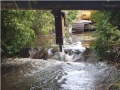 Weir removal.JPG 420 × 316; 45 KB
 Weir removal clayton vale.png 2,288 × 1,712; 9.77 MB
 Weir removal in progress 21-3-16.jpg 3,000 × 2,000; 1.88 MB
 Weirs Laudal.pdf ; 324 KB
 Weirs Vassbygdelva.jpeg 2,256 × 1,496; 915 KB
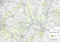 Welland catchment.JPG 1,617 × 1,144; 638 KB
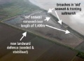
 Welwick managed realignment scheme 1.jpg 732 × 558; 64 KB
 Welwik 2.JPG 255 × 185; 9 KB
 Welwik 3.JPG 502 × 124; 11 KB
 Welwik 4.JPG 440 × 160; 13 KB
 Wensum River Tat.JPG 1,024 × 768; 444 KB
 Wensum Ryburgh.jpg 4,000 × 3,000; 3.83 MB
 Wensum Ryburgh Common meander loop.jpg 1,024 × 768; 369 KB
 Wensum Ryburgh End.JPG 1,024 × 768; 378 KB
 Wensum Swanton Morley floodplain re-connection.JPG 1,024 × 768; 316 KB
 West bank point cloud pic.JPG 901 × 588; 120 KB
 West lexham.png 1,017 × 351; 637 KB
 West pool 1.JPG 4,000 × 3,000; 2.25 MB
 West pool 2.JPG 4,000 × 3,000; 2.14 MB
 Westborough 1.png 787 × 553; 1.25 MB
 Westborough 2.png 787 × 562; 1.21 MB
 Westborough 3.png 1,040 × 582; 1.43 MB
- Westborough case study final.pdf ; 691 KB
 Wet Woodland at Ironbridge Farm.JPG 4,608 × 3,456; 6.34 MB
 Wet grassland creation. Fairfield.JPG 2,592 × 1,944; 2.11 MB
 Wet woodland.jpg 4,032 × 3,024; 5.24 MB
 Wetland.JPG 1,920 × 1,080; 534 KB
 Wetland area created to deal with problematic polluted area.JPG 2,592 × 1,936; 3.18 MB
 Wetland area created to deal with problematic polluted area (2).JPG 2,592 × 1,936; 1.99 MB
 Wetland area created to deal with problematic polluted area (3).JPG 2,592 × 1,936; 2.14 MB
 Wetland creation early stages.JPG 421 × 314; 32 KB
 Wetland site at Bocking Blackwater.jpg 3,264 × 2,448; 2.9 MB
 Wetlands-Project-During-Construction-in-July-23-photo-Belmont-Estate.jpeg 2,048 × 1,536; 745 KB
- WetlandsBroshure6.pdf ; 1.2 MB
 Wetlands - Kidston.png 681 × 616; 890 KB
 Wetlands Autumn 23.JPG 4,032 × 3,024; 5.07 MB
 Wettingen limmat1.jpg 598 × 890; 149 KB
 Wettingen limmat2.jpg 597 × 874; 127 KB
 Whip.jpg 300 × 200; 25 KB
 Whip2-map-overlay.gif 385 × 421; 42 KB
 White-clawed crayfish survey workshop.jpg 1,793 × 1,525; 832 KB
 White Claws.JPG 2,048 × 1,536; 647 KB
- Whitemills FINAL.pdf ; 1.37 MB
- Whitworths Mill Greening CS Final.pdf ; 1.02 MB
 Wide water margin, Tarland 2.JPG 3,920 × 2,204; 2.67 MB
- Wiki addition.pdf ; 229 KB
 WildWylye01.JPG 4,592 × 3,056; 6.88 MB
 WildWylye02.JPG 4,592 × 3,056; 5.84 MB


.JPG)
.JPG)


